Hyderabad Metro Map
Complete HMRL network map with all 3 lines, 57 stations and 3 interchanges. Pinch or scroll to zoom.
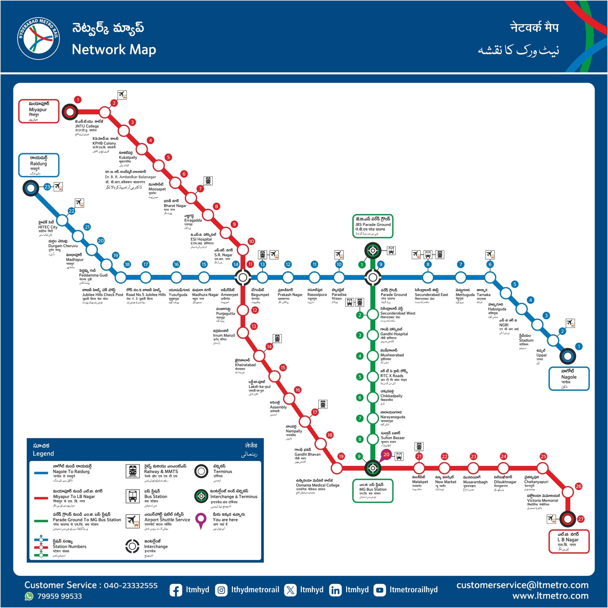
Pinch or scroll to zoom • Drag to pan • Double-tap to zoom in
The Hyderabad Metro, operated by L&T Metro Rail Hyderabad (HMRL), is one of the largest elevated metro systems in the world. Opened to the public in 2017, it spans roughly 69 km across three corridors — Red, Blue and Green lines — connecting 57 stations from Miyapur in the west to LB Nagar in the south-east, and from Nagole all the way to Raidurg near Gachibowli. The full route map above shows every station, every line, and the three interchange points where the network connects.
How to read the Hyderabad Metro map
Each metro line is colour-coded on the route map. Red runs from Miyapur in the west to LB Nagar in the south-east. Blue connects Nagole in the east to Raidurg in the west, passing through Hyderabad's main IT corridor. Green is the shortest line, linking Parade Ground to MG Bus Station.
Solid coloured circles mark regular stations. Larger or joined markers show interchange stations where two lines meet — Ameerpet, Parade Ground and MG Bus Station. At these stations you can transfer between lines without leaving the paid area or buying another ticket. Terminal stations (Miyapur, LB Nagar, Nagole, Raidurg, Parade Ground, MG Bus Station) are the endpoints of each line.
The three Hyderabad Metro lines
Red Line· Miyapur ↔ LB Nagar · 27 stations
The longest line on the network, the Red Line connects the western suburb of Miyapur with the south-eastern hub of LB Nagar, passing through Kukatpally, Ameerpet (interchange with Blue), MG Bus Station (interchange with Green) and Dilsukhnagar. End-to-end fare around ₹70 with a journey time of roughly 60 minutes.
Blue Line· Nagole ↔ Raidurg · 23 stations
The IT corridor line. Blue links Nagole in the east to Raidurg in the west, serving HITEC City, Madhapur, Jubilee Hills Check Post, Begumpet, Parade Ground (interchange with Green) and Ameerpet (interchange with Red). The Blue Line is the most-used line by commuters working in Hyderabad's tech hubs around Gachibowli and HITEC City.
Green Line· Parade Ground ↔ MG Bus Station · 9 stations
The shortest of the three, the Green Line runs from Parade Ground through Secunderabad West, RTC X Roads, Sultan Bazaar and ends at MG Bus Station. It connects the old city to the cantonment area and provides a direct interchange route to both the Blue (at Parade Ground) and Red (at MG Bus Station) lines.
Interchange stations
Three stations on the Hyderabad Metro route map act as interchanges — points where you can transfer between lines without leaving the paid area. The interchange platforms are connected by stairs, escalators and lifts within the same station.
- Ameerpet — the busiest interchange, connecting the Red and Blue lines. Most commuters going between west Hyderabad and the IT corridor change here.
- Parade Ground — connects the Blue and Green lines, useful for trips between the IT corridor and the cantonment area.
- MG Bus Station — connects the Red and Green lines. Next to MGBS bus terminal for onward bus travel.
Popular metro stations
Most-searched stations on the Hyderabad Metro route map. Tap any station for first/last train times, fares and a map of nearby landmarks.
HITEC City
Blue LineThe IT hub gateway — closest metro to Cyber Towers, Mindspace, and Inorbit Mall.
Ameerpet
Red ↔ BlueBusiest interchange. Transfer between Red and Blue lines here.
Secunderabad East
Blue LineWalking distance to Secunderabad railway station and Paradise.
MG Bus Station
Red ↔ GreenInterchange between Red and Green lines, next to MGBS bus terminal.
LB Nagar
Red LineEastern terminus of the Red Line, gateway to South-East Hyderabad.
Miyapur
Red LineWestern terminus of the Red Line, with depot and parking.
Raidurg
Blue LineWestern terminus near Gachibowli, last stop on the Blue Line.
Parade Ground
Blue ↔ GreenInterchange between Blue and Green lines, near Secunderabad.
Hyderabad Metro Map — FAQ
How many stations does the Hyderabad Metro have?
The Hyderabad Metro has 57 operational stations across three lines — Red Line (27 stations), Blue Line (23 stations) and Green Line (9 stations) — with 3 interchange stations connecting them.
What are the three Hyderabad Metro lines?
The three lines are the Red Line (Miyapur ↔ LB Nagar), the Blue Line (Nagole ↔ Raidurg) and the Green Line (Parade Ground ↔ MG Bus Station). Together they cover roughly 69 km across Hyderabad and Secunderabad.
Where are the Hyderabad Metro interchange stations?
There are three interchange points on the route map: Ameerpet (Red ↔ Blue), Parade Ground (Blue ↔ Green) and MG Bus Station (Red ↔ Green). You can transfer between lines at any of these stations without leaving the paid area.
What are the Hyderabad Metro operating hours?
Hyderabad Metro typically operates between 6:00 AM and 11:30 PM every day. Trains run every 3–5 minutes during peak hours and every 10–12 minutes during off-peak hours. See the full schedule on the Train Schedule page.
How do I read the Hyderabad Metro route map?
Each line is colour-coded — Red, Blue and Green. Solid coloured circles mark regular stations, and larger circles or joined markers indicate interchange stations where two lines meet. Terminal stations are the endpoints of each line.
Is there a Hyderabad Metro app for live tracking?
Yes — MetroTrack is the official live tracking app for Hyderabad Metro, available on Google Play. It tracks YOUR journey in real-time, offers wake-up call alerts before your stop, and works offline. Get the app from the home page.